


Ships sailed through Albemarle Sound
North Carolina
A dotted line on the 1755 map below runs through Albemarle Sound indicating the course for ships. It may be seen where they could escape to or enter from the Atlantic through the narrow, hazardous Roanoke Inlet.
At the left, near where the Chowan River empties into the Sound, is the town of Edenton. Several roads came together here, and the little black rectangles suggest buildings. There is a church in the town, with a tower and steeple in front. Other churches shown elsewhere on the map have exactly the same form as the one at Edenton, so one realizes that this form is not meant to show what a specific church looked like, but is a standard symbol for a church. Incidentally, notice how churches or chapels stand alone in various places in the countryside.
Courthouses, like churches, are shown in towns, and here and there in the country. They are indicated by a symbol which could be described as the letter “U” which is squared rather than rounded. The courthouse at Edenton is hard to identify; one can not be sure about it.
To the northeast of Edenton, on the Perquimans River, is 7the town of Hartford, now called Hertford. Farther to the east is Nixonton, its houses lying along both sides of a single road. Follow the road to the south and see the farms along Little River. Each farm is marked by a spot representing the house and carries the name of the owner—the names Morris, Evans, Ancoup, and so on, can be read. In the north, above this area, is the Great Dismal Swamp, looking very great and dismal indeed.
Vivid as this map proves to be, we have not seen individual towns very clearly. To get sharper ideas about them, we descend lower to the earth and look at maps from individual cities.
The Albemarle Sound region, is a detail from a famous map of North and South Carolina by Henry Mouzon, Jr., made in 1775. Like the previous map, it was printed in England and is also reproduced in a slightly smaller size than the original. Mr. Cumming states that it may be called the Revolutionary War map of North and South Carolina, because it was used by American, British, and French forces used it. So, in looking at the fragment, reproduced here, a person might imagine that he is a Revolutionary War general, studying the little towns, the ports, and roads that wander through the country, and trying to understand why a town is where it is, what military importance it has, or how it might be protected or destroyed.

1755 Mouzon Map. Albemarle Sound Region
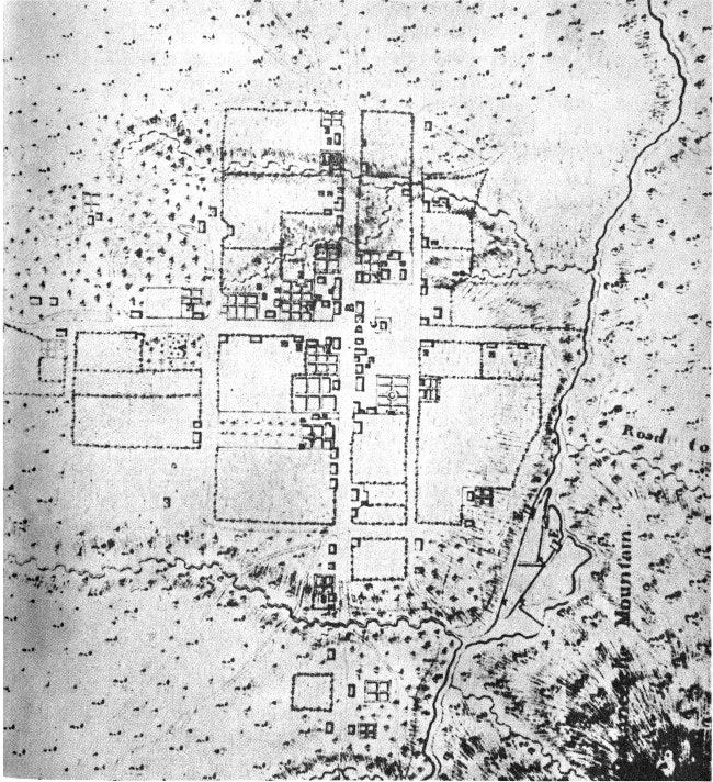
SAUTHIER’S “PLAN OF ... HILLSBOROUGH,” 1768.
The Sauthier map of Hillsboro, dated October 1768, was made after the spring uprising of the Regulators in that town and immediately following Governor Tryon’s arrival there in September. From this, it may be suspected that, in commissioning the map, Governor Tryon had military thoughts in mind. Hillsboro—the danger spot—was the first map in Sauthier’s series of ten maps. The others were made as he traveled with Governor Tryon.
Hillsboro is on the Eno River in the wooded land of Orange County. There are the Roads from Salisbury ... to Virginia ... to Halifax ... to New Bern ... to the Quaker Settlement, and to Cross Creek. Oakaneetche Mountain was a great hump of earth overlooking Hillsboro.
The Occoneechee mountains were the home of the Occoneechee Indians.
Sauthier’s Map of Hillsboro